Click below for more information

HOME PAGE
CHATEAU
HISTORY
HISTOIRE      
THE AREA
LOCAL ACTIVITIES
PHOTOS
St-FERRIOL IN ART
THE ASSOCIATION
EVENTS AT THE CHATEAU
VOLUNTEERS
THE CATHAR CONNECTION
GîTE ACCOMMODATION
GETTING THERE
MAPS
RESOURCES
CONTACT
 
Contact Us
Tel: + 33 (0)468 201142

e-mail


Château St-Ferriol
Late Medieval Castle in the South of France


Maps of the area around Château de St-Ferriol


The following maps show the location of St-Ferriol, homing in on the country (France), Region (The Langued-Roussillon) and Department (Aude). The larger map below shows links with nearby towns and cities.


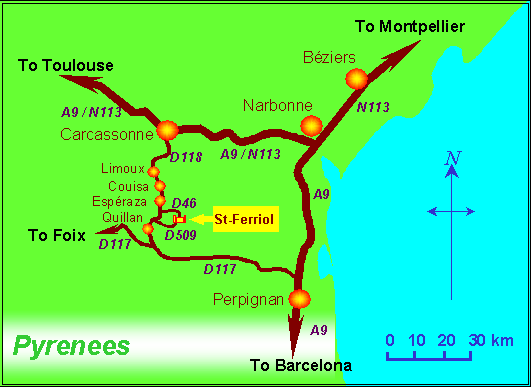
If you have GPS it might help to know the latitude and longitude of St-Ferriol:
Latitude: 42:53:31N (42.8918489) Longitude: 2:13:28E (2.224439)

Google Map at link


View Chateau de St Ferriol in a larger map


The Languedoc. Click here to open this site in a new window    
CSFWeb LinksContact by e-mail